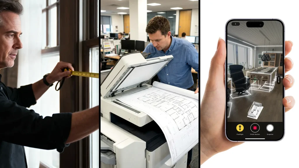
Building Information Modelling (BIM) is a method that is used throughout the entire life cycle of a building, from planning and construction through to operation and maintenance. It combines geometric and spatial data with a comprehensive database that stores key information like materials, room sizes, and system components. This database is a reliable basis for decision-making and improves the coordination and efficiency of all project participants.
At the same time, Scan-to-BIM is gaining in importance. This is because more and more companies and authorities are using BIM and tightening the regulations for it. This service is particularly important when it comes to updating existing buildings. Often there are no digital models for this but now Scan-to-BIM closes this gap. This significantly improves planning, coordination and cost management.
In this blog article, we look at the different types of 3D LiDAR scanners used in scan-to-BIM projects. We explain what these different scanners can do and how they are used.
What is Scan to BIM?
“Scan-to-BIM” is an advanced workflow in the architecture, engineering, and construction (AEC) industry that leverages modern 3D scanning technologies to digitally capture existing buildings and convert them into intelligent BIM models.
This process enables professionals to precisely document existing structures and align them with the latest planning and documentation methods. This saves time and makes collaboration more efficient and effective throughout the entire life cycle of a building.
3D scanning technologies are used for scanning, e.g. mobile or terrestrial LiDAR scanners. This allows the data of a building to be captured accurately and comprehensively. This technology usually generates a detailed point cloud data set that serves as the basis for the BIM model.
Terrestrial LiDAR Scanners
Terrestrial LiDAR Scanners, also known as static laser scanners, are among the expert devices in 3D capture technology. They are an integral part of the 3D scanner surveying industry.
The use of these scanners makes it possible to digitize complex environments quickly and with an impressive level of detail. These scanners are typically mounted on tripods and use a rotating laser to capture large areas from fixed viewpoints.
The result is a high-precision point cloud that serves as the basis for BIM models, CAD drawings and other applications that require precise dimensions and comprehensive documentation of physical reality.
Leica ScanStation P50

Max. Reach: more than 1 km
Scan Rate: 1 million points/second
Price: ~ € 83.131,–
The Leica ScanStation P50 is a powerful 3D laser scanning solution for industry professionals who want to survey even the most inaccessible locations safely and efficiently from a distance. With its impressive range and ability to deliver high-quality 3D data and HDR images, the scanner enables the capture of even the largest and most difficult to access infrastructure objects or open pit mines.
In addition to high performance and reliability in extreme environmental conditions, such as temperatures from -20 °C to +50 °C and an IP54 rating for dust and water protection, the ScanStation P50 offers a comprehensive scanning solution. An industry-leading 3D point cloud software suite powers the data processing, featuring Leica Cyclone stand-alone software, Leica JetStream, Leica CloudWorx, and the free Leica TruView. The solution also tightly integrates with the Cyclone FIELD 360 app, creating a seamless workflow from field acquisition to final data registration in the office.
API HemiScan

Max. Reach: 70 m
Scan Rate: 1,2 million points/second
Price: on request
The API HemiScan is a powerful 3D BIM scanner that is suitable for industrial and outdoor use. It scans up to 1.2 million points per second and reaches distances of up to 70 meters, delivering highly accurate measurements. With a resolution of 0.001 mm, it produces detailed, high-resolution 3D CAD models.
Users can export the scanned data to applications like PolyWorks®, RapidForm®, Geomagic®, Cyclone®, and RealWorks®. Its robust design and high mobility make the HemiScan ideal for precision-driven scanning tasks that demand both accuracy and reliability.
Artec Ray II
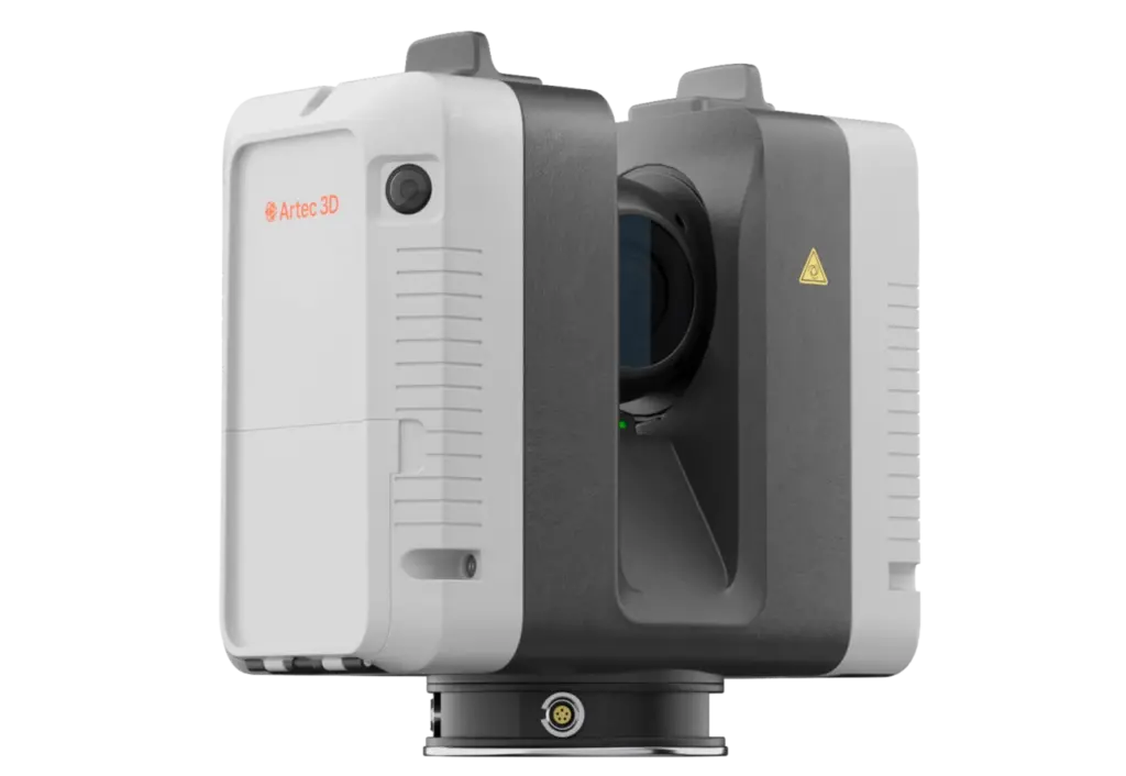
Max. Reach: 0,5-130 m
Scan Rate: 2 million points/second
Price: ~ €61.500,–
The Artec Ray II is a terrestrial 3D laser scanner with a range of up to 130 meters and an accuracy of less than 1.9 mm at a distance of 10 meters. It generates a dense, detailed point cloud in just 1.7 minutes and features three internal cameras with a combined resolution of 36 megapixels. Thanks to its built-in rechargeable batteries, which provide up to four hours of operation, the Ray II is ideal for use both indoors and outdoors.
In addition to its high performance, the Artec Ray II supports the combination of its scans with those of handheld scanners such as the ARTEC Eva, Spider or Leo, making it easier to capture smaller or hard-to-reach areas. Data processing takes place in the powerful ARTEC Studio software, where users can edit the results directly and export them for applications such as reverse engineering in programs like Geomagic Design X, SolidWorks or ReCap.
FARO Focus Premium

Max. Reach: 70 m, expandable to 350 m
Scan Rate: 2 million points/second
Price: ~ € 40.200,–
The FARO Focus Premium is a high-performance 3D laser scanner. Depending on the setting, a scan can be completed in just around one minute. This scanner combines a range of up to 70 m, which can be extended to up to 350 m with an optional range extension, and a maximum scanning speed of up to two million points per second.
The FARO Focus Premium not only facilitates fast data capture, but also subsequent data processing and sharing within teams. Scanner control and data processing can be done via the FARO Stream app for Android and iOS, while final data registration is done via FARO Scene, eliminating the need for office processing.
Teledyne Optech CMS V500
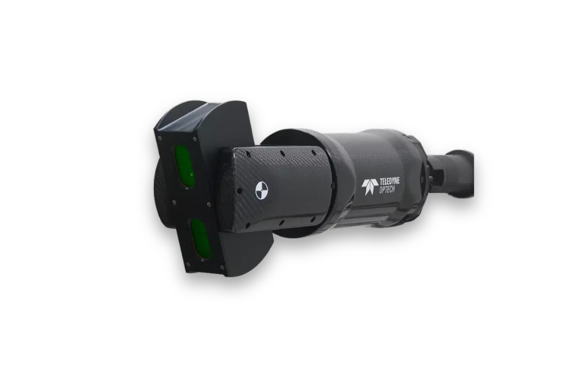
Max. Reach: 0,5 – 500 m
Scan Rate: 160 points/second
Price: on request
The Teledyne Optech CMS V500 is a terrestrial 3D LiDAR scanner designed for high-precision underground cavity monitoring rather than high-speed surface scanning. Its scan parameters are optimized for detailed, accurate 3D modeling of inaccessible or dangerous areas, typically in mining environments.
The scan rate of this scanner is significantly lower than the scan rates of general-purpose terrestrial LiDAR scanners, which can reach millions of points per second. The CMS V500’s strength lies in its ruggedness, safety, and ability to operate in harsh, underground environments—not in rapid data acquisition
Handscanner
Handheld scanners are small, portable devices that can be used to collect three-dimensional information from objects and environments. The devices are compact and mobile, and you can simply hold them and move them over the surface of the object you want to scan. They are particularly useful for capturing data in complex or hard-to-reach areas. Handheld scanners are ideal for fast, efficient scanning of smaller or detailed objects and often offer the ability to immediately visualize and edit the captured data.
Dotproduct DPI-10 KIT

Max. Reach: 0,6-3,7 m
Scan Rate: Real-time detection
Price: ~ € 2.500,–
The DotProduct DPI-10 Kit is an advanced, handheld 3D imaging system that can capture objects and environments in real time. Equipped with a PrimeSense Carmine 1.08 camera and supported by Dot3D™ software, this system transforms a Samsung Galaxy S6 or Windows Go tablet into a powerful and easy-to-use handheld scanner.
Data is processed and registered directly on the tablet, allowing users to define coordinate systems, register multiple data sets on site and take measurements instantly. The Dot3D™ software uses advanced algorithms for simultaneous localization and mapping to transfer 3D reconstructions and localizations to the mobile device in real time.
Intel Realsense D455 KIT
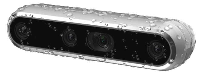
Max. Reach: 0,6 – 6,0 m
Scan Rate: up to 90 fps
Price: ~ € 431,–
The Intel® RealSense™ D457 kit is the latest model in the D400 series and benefits from over a decade of experience and customer feedback on stereo cameras. The D457 has an IP65 grade enclosure protecting it from dust ingress and projected water. It features LiDAR technology with an integrated RGB sensor and an IMU that enables precise 3D data capture in the range of 0.6 to 6.0 meters.
The kit is uses the Intel RealSense SDK 2.0, a free, cross-platform software development kit designed for Intel RealSense depth camera. It enables developers to easily access and process depth and color data streams, and provides tools for camera configuration, calibration, and debugging.
FARO Freestyle 2

Max. Reach: 0,4-10 m
Scan Rate: 220.000 points/second
Price: on request
The FARO Freestyle 2 is a handheld 3D scanner that captures fast, photorealistic 3D data and visualizes it in real time. With a scanning range of 0.4 to 10 meters, it allows users to scan intuitively without needing additional hardware—everything displays directly on the device.
The Freestyle 2 delivers high quality, full color 3D data with up to 0.5 mm accuracy. It provides haptic feedback and live scan quality visuals to keep users informed throughout the process. Advanced tracking algorithms support natural movement during scanning and enable efficient integration with professional software like FARO Scene for further analysis.
Mobile LiDAR Scanners
Mobile laser scanners capture the environment while you are moving, for example walking around the room. The more complex scanners are very dependent on the hardware. They consist of a measuring head, one or more laser scanners and various cameras or panoramic cameras. In order for the sensor to know where it is, it also needs GPS antennas and an inertial navigation system (IMU – Inertial Measurement Unit).
Metaroom® Scan App
Metaroom Scan app. Source: https://amrax.ai/
Max. Reach: 5 m
Scan Rate: Real-time detection
Metaroom® Scan App: Free
Metaroom® Workspace Price: from € 9,90–/month
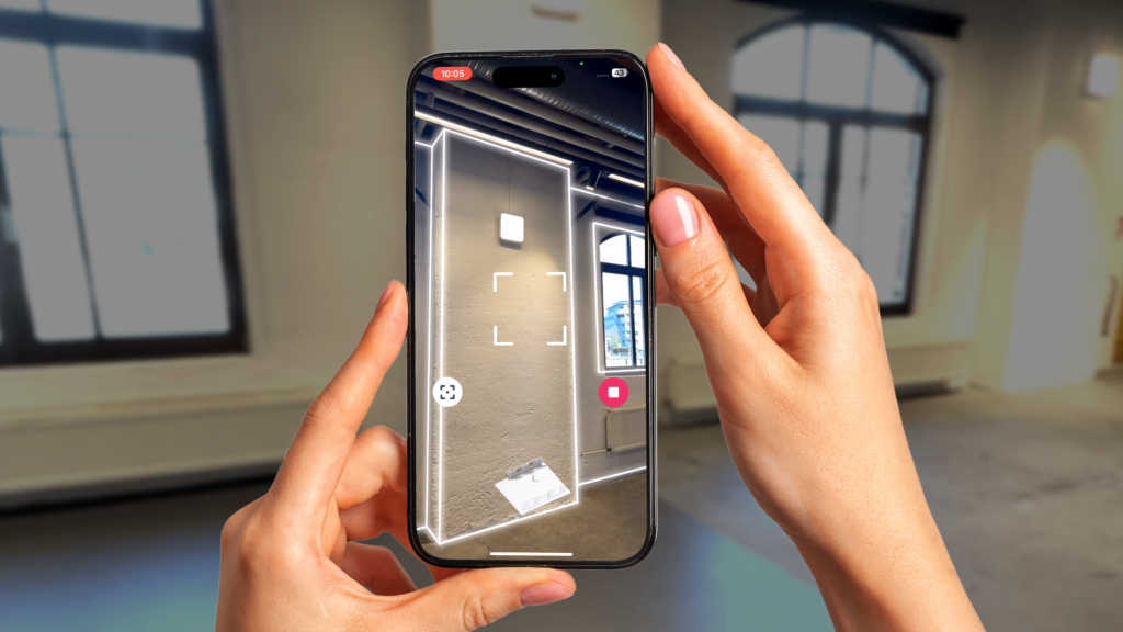
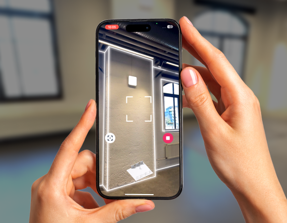
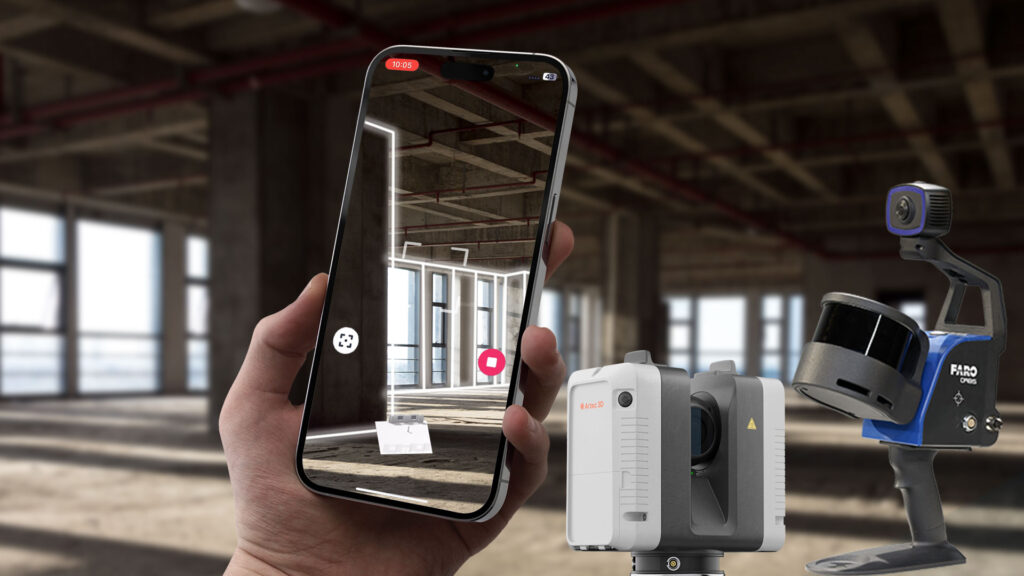
The Metaroom®Scan App is a professional-grade 3D scanning application designed for Apple devices equipped with LiDAR sensors, such as iPhone 12 Pro and later models, and iPad Pro models from 2020 onward. It enables users to quickly and accurately digitize indoor spaces, including single rooms, multi-room setups, entire floors, or even whole buildings, by simply scanning with their devices.
With the Metaroom Scan App, users can create a complete 3D model of a building by scanning it room by room. The app captures every floor in detail and automatically merges the scans into a comprehensive 3D model. This process thoroughly documents the building’s structure and provides clear guidance to ensure complete coverage.
During the scanning process, users can highlight important areas and features in the building by taking Snapshots of these areas. These are then precisely located in the model. After completing the scan, the app uploads the data to the cloud for processing. It then generates a CAD-ready 3D model that users can enrich with additional details and specifications in the Metaroom® Workspace. Finally, users can export the processed models in various formats, allowing seamless integration into BIM and CAD software, making the entire workflow from capture to planning fast, easy, and efficient.
FARO Orbis

Max. Reach: 120 m
Scan Rate: 640.000 points/second
Price: ~ € 48.458,–
The FARO Orbis combines the advantages of terrestrial laser scanning with mobile SLAM (Simultaneous Localization and Mapping) technology. This innovative combination enables up to ten times faster data acquisition compared to traditional methods.
With a maximum range of 120 meters and an acquisition rate of 640,000 points per second, the Orbis delivers both the speed of SLAM technology and the high accuracy of terrestrial scanning thanks to the integrated FARO Flash technology.
ZEB Horizon

Max. Reach: 100 m
Scan Rate: 300.000 points/second
Price: on request
The ZEB Horizon and ZEB Horizon RT are the latest mobile laser scanners from GeoSLAM, specially designed for outdoor and indoor applications. With a range of up to 100 meters, these devices are perfect for data collection in large open spaces as well as in GPS-poor environments.
Operation of the scanner is intuitive, and data evaluation takes place directly on site, which enables flexible use – for example, on drones, vehicles, or simply on foot. The scanner captures 300,000 points per second with an accuracy of up to 6 mm and comes with the GeoSLAM Connect and GeoSLAM Draw software, which enable automatic registration and fast evaluation of the scan data.
The following table provides a clear overview of the most important features of the eleven scanners discussed:
| Scanner | Max. Reach | Scan Rate (points/second) | Price | Special Features |
| FARO Focus Premium | up to 350 m | up to 2 Mio. | €40,200 | High-Speed-SSD, robust, GeoSLAM-Technology |
| TELEDYNE OPTECH CMS V500 | 0,5 – 500 m | 160 | Unknown | Suitable for inaccessible or underground cavity monitoring |
| ARTEC Ray II | up to 130 m | up to 1,2 Mio. | €61,500 | Portable, lightweight, high-resolution 3D CAD models possible |
| DotProduct DPI-10 Kit | 0,6 – 3,7 m | Real-time | €2,500 | Handheld, for small and hard-to-reach areas |
| Intel® RealSense™ D457 Kit | 0,4 – 4,2 m | up to 90 fps | €431 | Integrated RGB camera, LiDAR, supports various formats |
| FARO Freestyle 2 | 0,4 – 10 m | 220.000 | Unknown | Portable, lightweight, suitable for indoor and outdoor use |
| ZEB Horizon / ZEB Horizon RT | up to 100 m | 300.000 | Uknown | Real-time feedback, lightweight, suitable for UAVs |
| FARO Orbis | up to 120 m | 640.000 | €48,458 | Hybrid of terrestrial and mobile scanning |
| Leica ScanStation P50 | more than 1 km | 1 Mio. | €83,131 | Extremely robust, for long distances |
| Metaroom® Solution | 10 m | Real-time | from €29,90/month | Cost-effective, no expert knowledge required, uses Apple Pro devices, no additional devices required, many export formats, no additional software required |
| FARO Focus S70 | up to 70 m | 976.000 | Unknown | Accurate, fast, for precise measurements and documentation |
Conclusion
The use of 3D laser scanning technologies has significantly advanced the field of Building Information Modeling (BIM). These technologies, also known as Scan-to-BIM, enable the capture of existing building structures. The data can then be used for construction planning, renovations or maintenance. This technology is particularly advantageous when scanning buildings that lack digital models. This enables the creation of a precise planning basis, improving coordination and cost management.
Many of the LiDAR scanners presented here are high-performance devices located in the high-end segment, primarily used in professional surveying. These devices are therefore used by experts.
Mobile LiDAR scanners offer a powerful yet cost-efficient alternative for building digitization.
Among them, Metaroom’s mobile solution stands out for its ease of use and flexibility. Using standard Apple Pro devices, it enables the creation of detailed 3D building models by capturing each room in a structured workflow. This method not only streamlines the process but also reduces costs by eliminating the need for expensive, specialized equipment. Metaroom seamlessly integrates captured data into leading BIM software, providing valuable support to professionals throughout every stage of the building lifecycle, from planning and design to renovation.
In summary, modern 3D laser scanners offer an indispensable resource for building information modeling. Not only do they greatly simplify the capture process, but they also optimize the subsequent planning and construction phases. With such technological advances, accuracy is improved and the capabilities of BIM are enhanced, ultimately leading to more efficient and cost-effective construction projects.
Updated 2nd october, 2025